Geolocate

Mountain Ranch topographic map

Click on the map to display elevation.

About this map

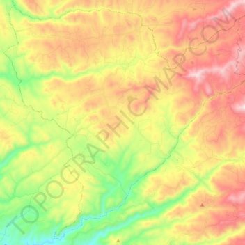
Name: Mountain Ranch topographic map, elevation, terrain.

Location: Mountain Ranch, Calaveras County, California, United States (38.19203 -120.55881 38.23128 -120.50874)

Average elevation: 656 m

Minimum elevation: 465 m

Maximum elevation: 819 m

Other topographic maps

Click on a map to view its topography, its elevation and its terrain.

Dorrington

United States > California > Calaveras County

According to the United States Census Bureau, the CDP has a total area of 3.7 square miles (9.6 km2), 99.86% of it land. The elevation is 4,800 feet ASL.

Average elevation: 1,464 m

Ganns

United States > California > Calaveras County

Average elevation: 1,998 m

Big Valley

United States > California > Calaveras County

Average elevation: 746 m

Sandoz

United States > California > Calaveras County

Average elevation: 952 m

Tamarack

United States > California > Calaveras County

Average elevation: 2,136 m

Arnold

United States > California > Calaveras County > Arnold

Average elevation: 1,171 m

Manuel Mill

United States > California > Calaveras County > Arnold

Average elevation: 1,229 m

Arnold

United States > California > Calaveras County > Arnold

Average elevation: 1,171 m

Camp Connell

United States > California > Calaveras County

Average elevation: 1,542 m

Dorrington

United States > California > Calaveras County

According to the United States Census Bureau, the CDP has a total area of 3.7 square miles (9.6 km2), 99.86% of it land. The elevation is 4,800 feet ASL.

Average elevation: 1,464 m

Manuel Mill

United States > California > Calaveras County > Arnold

Average elevation: 1,229 m

Fly-In Acres

United States > California > Calaveras County

Average elevation: 1,191 m

Murphys

United States > California > Calaveras County

"MURPHY'S CAMP is a curious old mining-town in Calaveras County, at an elevation of 2,400 feet (730 m) above the sea, situated like a nest in the center of a rough, gravelly region, rich in gold. Granites, slates, lavas, limestone, iron ores, quartz veins, auriferous gravels, remnants of dead fire-rivers and…

Average elevation: 702 m

Burson

United States > California > Calaveras County

Average elevation: 135 m

Tamarack

United States > California > Calaveras County

Average elevation: 2,136 m

Funk Hill

United States > California > Calaveras County

Average elevation: 431 m

Fort Jones

United States > California > Calaveras County

Average elevation: 980 m

Avery

United States > California > Calaveras County > Avery

Average elevation: 1,012 m

Murphys

United States > California > Calaveras County > Murphys

"MURPHY'S CAMP is a curious old mining-town in Calaveras County, at an elevation of 2,400 feet (730 m) above the sea, situated like a nest in the center of a rough, gravelly region, rich in gold. Granites, slates, lavas, limestone, iron ores, quartz veins, auriferous gravels, remnants of dead fire-rivers and…

Average elevation: 702 m

Gear up for your next adventure:

🪫Rechargeable Headlamps - USB rechargeable headlamps
👕UPF 50+ Sun Shirts - Essential protection against the harsh Australian sun during field work
🧥Thermal Emergency Blankets - Compact Mylar blankets to prevent hypothermia if stranded overnight
📱Shockproof Phone Cases - Extra protection for your smartphone against drops on rocky terrain
🪑Portable Backpacking Chairs - A comfortable seat for studying maps at the end of the day

As an Amazon Associate, this site earns from qualifying purchases at no extra cost to you.