Geolocate

Poway topographic map

Click on the map to display elevation.

About this map

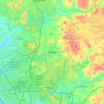
Name: Poway topographic map, elevation, terrain.

Location: Poway, San Diego County, California, 92064, United States (32.80282 -117.19586 33.12282 -116.87586)

Average elevation: 241 m

Minimum elevation: 3 m

Maximum elevation: 898 m

Gear up for your next adventure:

🦯Adjustable Trekking Poles - Reduce impact on knees when descending steep topographic ridges
🌿Flora and Fauna Field Guides - Identify the plants and animals you encounter on your route
📱Tablet Tripod Mounts - Steady platforms for viewing digital maps or taking long exposures
🔪Camping Knives - Multi-purpose outdoor knives
🧦Hiking Socks - Comfortable socks for long hikes

As an Amazon Associate, this site earns from qualifying purchases at no extra cost to you.