Geolocate

Sola topographic map

Click on the map to display elevation.

About this map

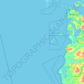
Name: Sola topographic map, elevation, terrain.

Location: Sola, Rogaland, Norway (58.78215 5.00766 58.98209 5.70299)

Average elevation: 4 m

Minimum elevation: 0 m

Maximum elevation: 111 m

Other topographic maps

Click on a map to view its topography, its elevation and its terrain.

Tau

Norway > Rogaland

Average elevation: 58 m

Suldalsosen

Norway > Rogaland

Average elevation: 315 m

Aukland

Norway > Rogaland

Average elevation: 43 m

Ølen

Norway > Rogaland

Average elevation: 143 m

Månafossen

Norway > Rogaland

Average elevation: 409 m

Årabrot

Norway > Rogaland > Haugesund

Average elevation: 16 m

Egersund

Norway > Rogaland

Average elevation: 68 m

Austevik

Norway > Rogaland > Håvik

Average elevation: 14 m

Aukland

Norway > Rogaland

Average elevation: 260 m

Gear up for your next adventure:

🚗Car Camping Gear - Equipment for vehicle camping
🌿Flora and Fauna Field Guides - Identify the plants and animals you encounter on your route
🎒3L Hydration Reservoirs - Hands-free drinking to stay hydrated on steep contour climbs
🔥Camping Stoves - Portable stoves for outdoor cooking
👟Lightweight Trail Runners - Agile footwear for fast movement over rugged Australian terrain

As an Amazon Associate, this site earns from qualifying purchases at no extra cost to you.