Geolocate

Zeitz topographic map

Click on the map to display elevation.

About this map

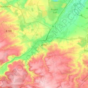
Name: Zeitz topographic map, elevation, terrain.

Location: Zeitz, Burgenlandkreis, Saxony-Anhalt, Germany (50.97121 12.04578 51.13014 12.27785)

Average elevation: 210 m

Minimum elevation: 118 m

Maximum elevation: 303 m

Other topographic maps

Click on a map to view its topography, its elevation and its terrain.

Aue

Germany > Saxony-Anhalt > Burgenlandkreis > Zeitz

Average elevation: 174 m

Gear up for your next adventure:

🔋Solar Power Banks - Solar chargers for outdoors
🥾Trail Running Shoes - Shoes for trail running
👕UPF 50+ Sun Shirts - Essential protection against the harsh Australian sun during field work
🩹Wilderness First Aid Kits - Comprehensive medical kits tailored for hiking and remote exploration
🥤Hydration Packs - Hydration systems for hiking

As an Amazon Associate, this site earns from qualifying purchases at no extra cost to you.