Geolocate

Calizzano topographic map

Click on the map to display elevation.

About this map

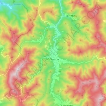
Name: Calizzano topographic map, elevation, terrain.

Location: Calizzano, Savona, Liguria, Italy (44.20298 8.06406 44.28225 8.20314)

Average elevation: 896 m

Minimum elevation: 502 m

Maximum elevation: 1,340 m

Other topographic maps

Click on a map to view its topography, its elevation and its terrain.

Vara Inferiore

Italy > Liguria > Savona

Average elevation: 793 m

Vara Superiore

Italy > Liguria > Savona

Average elevation: 819 m

Biestro

Italy > Liguria > Savona > Pallare

Average elevation: 581 m

Gear up for your next adventure:

🕯️Emergency Whistles - Safety whistles for hiking
🚴Cycling Backpacks - Backpacks for cyclists
🥤Outdoor Water Bottles - Reusable bottles for outdoor activities
🎒Tactical Waist Packs - Quick access to your compass, phone, and snacks while walking
🧭Military Style Lensatic Compass - Durable sighting compasses for advanced land navigation and surveying

As an Amazon Associate, this site earns from qualifying purchases at no extra cost to you.