
Throop topographic map
Click on the map to display elevation.
About this map
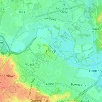
Name: Throop topographic map, elevation, terrain.
Average elevation: 13 m
Minimum elevation: 1 m
Maximum elevation: 40 m
Other topographic maps
Click on a map to view its topography, its elevation and its terrain.
Christchurch
United Kingdom > England > Bournemouth, Christchurch and Poole > Hurn
Average elevation: 18 m
East Parley Common
United Kingdom > England > Bournemouth, Christchurch and Poole > Hurn
Average elevation: 13 m
Upton Heath Nature Reserve
United Kingdom > England > Bournemouth, Christchurch and Poole > Poole
Average elevation: 40 m
Redhill Park
United Kingdom > England > Bournemouth, Christchurch and Poole > Bournemouth > Talbot Village
Average elevation: 33 m
Hamworthy Park
United Kingdom > England > Bournemouth, Christchurch and Poole > Poole
Average elevation: 2 m
Kings Park
United Kingdom > England > Bournemouth, Christchurch and Poole > Bournemouth
Average elevation: 31 m
Christchurch
United Kingdom > England > Bournemouth, Christchurch and Poole > Christchurch
Average elevation: 8 m
Christchurch
United Kingdom > England > Bournemouth, Christchurch and Poole > Christchurch
Average elevation: 18 m
Christchurch
United Kingdom > England > Bournemouth, Christchurch and Poole > Hurn
Average elevation: 18 m
Island in the Stour
United Kingdom > England > Bournemouth, Christchurch and Poole > Poole > Merley
Average elevation: 28 m
Christchurch
United Kingdom > England > Bournemouth, Christchurch and Poole > Hurn
Average elevation: 18 m