
Thank you for supporting this site ❤️
Make a donation
Make a donation
Gear up for your next adventure:
As an Amazon Associate, this site earns from qualifying purchases at no extra cost to you.
Bandarawela topographic map
Click on the map to display elevation.
Thank you for supporting this site ❤️
Make a donation
Make a donation
Gear up for your next adventure:
As an Amazon Associate, this site earns from qualifying purchases at no extra cost to you.
About this map
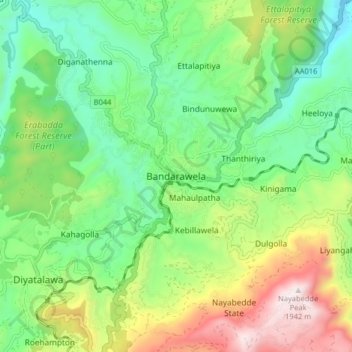
Name: Bandarawela topographic map, elevation, terrain.
Location: Bandarawela, Badulla District, Uva Province, 90100, Sri Lanka (6.79048 80.94882 6.87048 81.02882)
Average elevation: 1,293 m
Minimum elevation: 948 m
Maximum elevation: 1,943 m
Thank you for supporting this site ❤️
Make a donation
Make a donation
Gear up for your next adventure:
As an Amazon Associate, this site earns from qualifying purchases at no extra cost to you.