Geolocate

Lavagna topographic map

Click on the map to display elevation.

About this map

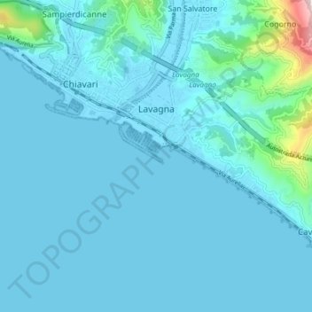
Name: Lavagna topographic map, elevation, terrain.

Location: Lavagna, Genoa, Liguria, Italy (44.28353 9.33178 44.32430 9.40717)

Average elevation: 42 m

Minimum elevation: -3 m

Maximum elevation: 529 m

Other topographic maps

Click on a map to view its topography, its elevation and its terrain.

Ligurian Apennines

Italy > Liguria > Genoa > Rezzoaglio

Average elevation: 1,187 m

Colla di Praglia

Italy > Liguria > Genoa > Ceranesi

Average elevation: 770 m

Lago Riane

Italy > Liguria > Genoa > Santo Stefano d'Aveto

Average elevation: 1,333 m

Erzelli

Italy > Liguria > Genoa > Genoa

Average elevation: 52 m

Genoa

Italy > Liguria > Genoa > Genoa

The city of Genoa covers an area of 243 square kilometres (94 sq mi) between the Ligurian Sea and the Apennine Mountains. The city stretches along the coast for about 30 kilometres (19 mi) from the neighbourhood of Voltri to Nervi, and for 10 kilometres (6.2 mi) from the coast to the north along the valleys…

Average elevation: 247 m

Ferriera

Italy > Liguria > Genoa > Arenzano

Average elevation: 47 m

Villetta Di Negro

Italy > Liguria > Genoa > Genoa

Average elevation: 53 m

Gear up for your next adventure:

🪫Rechargeable Headlamps - USB rechargeable headlamps
🧺Waterproof Dry Sacks - Organize your pack and keep electronics safe from rain and river crossings
🧥Softshell Jackets - Flexible outdoor jackets
📱Shockproof Phone Cases - Extra protection for your smartphone against drops on rocky terrain
🧭Military Style Lensatic Compass - Durable sighting compasses for advanced land navigation and surveying

As an Amazon Associate, this site earns from qualifying purchases at no extra cost to you.