Geolocate

Ishpatina Ridge topographic map

Click on the map to display elevation.

About this map

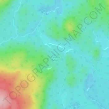
Name: Ishpatina Ridge topographic map, elevation, terrain.

Location: Ishpatina Ridge, Unorganized West Timiskaming, Timiskaming District, Northeastern Ontario, Ontario, Canada (47.35341 -80.69652 47.35351 -80.69642)

Average elevation: 429 m

Minimum elevation: 375 m

Maximum elevation: 600 m

Other topographic maps

Click on a map to view its topography, its elevation and its terrain.

Gear up for your next adventure:

📸Action Cameras - Record your journey across interesting topographic features in 4K
📱Tablet Tripod Mounts - Steady platforms for viewing digital maps or taking long exposures
🔪Outdoor Multi-tools - Versatile tools for gear repair and survival tasks in the wilderness
🦯Adjustable Trekking Poles - Reduce impact on knees when descending steep topographic ridges
🦟Insect Repellent - Protection against insects

As an Amazon Associate, this site earns from qualifying purchases at no extra cost to you.