Geolocate

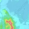
Rayta topographic map

Click on the map to display elevation.

About this map

Name: Rayta topographic map, elevation, terrain.

Location: Rayta, Girwa Tehsil, Udaipur, Rajasthan, India (24.54104 73.55031 24.58104 73.59031)

Average elevation: 862 m

Minimum elevation: 646 m

Maximum elevation: 1,065 m

Other topographic maps

Click on a map to view its topography, its elevation and its terrain.
Pratap Park

India > Rajasthan > Girwa Tehsil > Udaipur

Average elevation: 608 m

Jungle Safari Park

India > Rajasthan > Girwa Tehsil > Udaipur

Average elevation: 620 m

Gear up for your next adventure:

🥾Hiking Boots - Durable hiking boots for trails and rough terrain
📚Map Reading & Navigation Guides - Master the art of interpreting topographic contours and symbols
🎒3L Hydration Reservoirs - Hands-free drinking to stay hydrated on steep contour climbs
🥤Hydration Packs - Hydration systems for hiking
🔋Solar Power Banks - Charge your phone and GPS using the sun while deep in the bush

As an Amazon Associate, this site earns from qualifying purchases at no extra cost to you.