
Tramagal topographic map
Interactive map
Click on the map to display elevation.
About this map
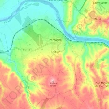
Name: Tramagal topographic map, elevation, terrain.
Location: Tramagal, Abrantes, Santarém, 2205-707, Portugal (39.41114 -8.29784 39.47532 -8.22191)
Average elevation: 93 m
Minimum elevation: 13 m
Maximum elevation: 188 m
Other topographic maps
Click on a map to view its topography, its elevation and its terrain.
Vale Zebrinho
Portugal > Santarém > Abrantes
Vale Zebrinho, São Facundo e Vale das Mós, Abrantes, Santarém, Portugal
Average elevation: 160 m
Rio de Moinhos
Portugal > Santarém > Abrantes
Rio de Moinhos, Abrantes, Santarém, 2200-799, Portugal
Average elevation: 70 m
Arreciadas
Portugal > Santarém > Abrantes
Arreciadas, São Miguel do Rio Torto e Rossio ao Sul do Tejo, Abrantes, Santarém, 2205-013, Portugal
Average elevation: 86 m
São Facundo
Portugal > Santarém > Abrantes > São Facundo
São Facundo, Abrantes, Santarém, Portugal
Average elevation: 185 m
Alferrarede
Portugal > Santarém > Abrantes
Alferrarede, Abrantes, Santarém, Portugal
Average elevation: 94 m