
Parque Nacional Iztaccíhuatl-Popocatépetl topographic map
Interactive map
Click on the map to display elevation.
About this map
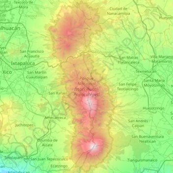
Name: Parque Nacional Iztaccíhuatl-Popocatépetl topographic map, elevation, terrain.
Average elevation: 2,665 m
Minimum elevation: 1,542 m
Maximum elevation: 5,371 m
Other topographic maps
Click on a map to view its topography, its elevation and its terrain.
San Rafael
México > Estado de México > Tlalmanalco
San Rafael, Tlalmanalco, Estado de México, 56740, México
Average elevation: 2,723 m