
Make a donation
Gear up for your next adventure:
As an Amazon Associate, this site earns from qualifying purchases at no extra cost to you.
Windermere Lake topographic map
Click on the map to display elevation.
Make a donation
Gear up for your next adventure:
As an Amazon Associate, this site earns from qualifying purchases at no extra cost to you.
About this map
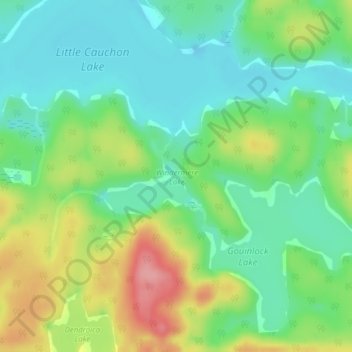
Name: Windermere Lake topographic map, elevation, terrain.
Average elevation: 355 m
Minimum elevation: 317 m
Maximum elevation: 424 m
Make a donation
Gear up for your next adventure:
As an Amazon Associate, this site earns from qualifying purchases at no extra cost to you.
Other topographic maps
Click on a map to view its topography, its elevation and its terrain.
Bissett Lake
Canada > Ontario > Nipissing District > Unorganized South Nipissing
Average elevation: 367 m
Cedar Lake
Canada > Ontario > Nipissing District > Unorganized South Nipissing
Average elevation: 370 m
Maple Leaf Lake
Canada > Ontario > Nipissing District > Unorganized South Nipissing
Average elevation: 510 m
Sunday Lake
Canada > Ontario > Nipissing District > Unorganized South Nipissing
Average elevation: 464 m
Make a donation
Gear up for your next adventure:
As an Amazon Associate, this site earns from qualifying purchases at no extra cost to you.
Sheriff Pond
Canada > Ontario > Nipissing District > Unorganized South Nipissing
Average elevation: 456 m
Moccasin Lake
Canada > Ontario > Nipissing District > Unorganized South Nipissing
Average elevation: 465 m
Make a donation
Gear up for your next adventure:
As an Amazon Associate, this site earns from qualifying purchases at no extra cost to you.
Bridle Lake
Canada > Ontario > Nipissing District > Unorganized South Nipissing
Average elevation: 430 m
Rowan Lake
Canada > Ontario > Nipissing District > Unorganized South Nipissing
Average elevation: 281 m
Guthrie Lake
Canada > Ontario > Nipissing District > Unorganized South Nipissing
Average elevation: 299 m
Make a donation
Gear up for your next adventure:
As an Amazon Associate, this site earns from qualifying purchases at no extra cost to you.
Radiant Lake
Canada > Ontario > Nipissing District > Unorganized South Nipissing
Average elevation: 295 m
Kawawaymog Lake
Canada > Ontario > Nipissing District > Unorganized South Nipissing
Average elevation: 385 m
Cedar Lake
Canada > Ontario > Nipissing District > Unorganized South Nipissing
Average elevation: 370 m
Madawaska Highlands
Canada > Ontario > Nipissing District > Unorganized South Nipissing
Average elevation: 371 m
Make a donation
Gear up for your next adventure:
As an Amazon Associate, this site earns from qualifying purchases at no extra cost to you.
Wenona Lake
Canada > Ontario > Nipissing District > Unorganized South Nipissing
Average elevation: 467 m
Biggar Lake
Canada > Ontario > Nipissing District > Unorganized South Nipissing
Average elevation: 409 m
Crotch Lake
Canada > Ontario > Nipissing District > Unorganized South Nipissing
Average elevation: 414 m
Ralph Bice Lake
Canada > Ontario > Nipissing District > Unorganized South Nipissing
Average elevation: 464 m
Make a donation
Gear up for your next adventure:
As an Amazon Associate, this site earns from qualifying purchases at no extra cost to you.