
Hatrival topographic map
Interactive map
Click on the map to display elevation.
About this map
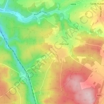
Name: Hatrival topographic map, elevation, terrain.
Location: Hatrival, Saint-Hubert, Neufchâteau, Luxemburg, Wallonië, België (49.97975 5.28990 50.02280 5.36952)
Average elevation: 437 m
Minimum elevation: 320 m
Maximum elevation: 567 m
Other topographic maps
Click on a map to view its topography, its elevation and its terrain.
Awenne
België > Luxemburg > Neufchâteau > Saint-Hubert
Awenne, Saint-Hubert, Neufchâteau, Luxemburg, Wallonië, België
Average elevation: 375 m