
Make a donation
Gear up for your next adventure:
As an Amazon Associate, this site earns from qualifying purchases at no extra cost to you.
Victor Island topographic map
Click on the map to display elevation.
Make a donation
Gear up for your next adventure:
As an Amazon Associate, this site earns from qualifying purchases at no extra cost to you.
About this map
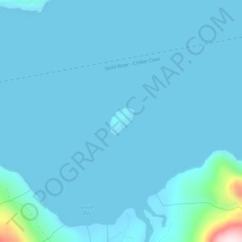
Name: Victor Island topographic map, elevation, terrain.
Average elevation: 26 m
Minimum elevation: -2 m
Maximum elevation: 493 m
Make a donation
Gear up for your next adventure:
As an Amazon Associate, this site earns from qualifying purchases at no extra cost to you.
Other topographic maps
Click on a map to view its topography, its elevation and its terrain.
Upana Caves
Canada > British Columbia > Strathcona Regional District > Area A (Kyuquot/Nootka/Sayward)
Average elevation: 684 m
Cachalot
Canada > British Columbia > Strathcona Regional District > Area A (Kyuquot/Nootka/Sayward)
Average elevation: 386 m
Alder Grove Recreation Site
Canada > British Columbia > Strathcona Regional District > Area A (Kyuquot/Nootka/Sayward)
Average elevation: 232 m
Muchalat Lake
Canada > British Columbia > Strathcona Regional District > Area A (Kyuquot/Nootka/Sayward)
Average elevation: 535 m
Make a donation
Gear up for your next adventure:
As an Amazon Associate, this site earns from qualifying purchases at no extra cost to you.