
Bécancour topographic map
Interactive map
Click on the map to display elevation.
About this map
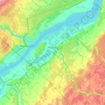
Name: Bécancour topographic map, elevation, terrain.
Location: Bécancour, Bécancour (MRC), Centre-du-Québec, Quebec, Canada (46.19450 -72.61107 46.45232 -72.15862)
Average elevation: 39 m
Minimum elevation: -1 m
Maximum elevation: 120 m
Other topographic maps
Click on a map to view its topography, its elevation and its terrain.
Sainte-Françoise
Canada > Quebec > Bécancour (MRC)
Sainte-Françoise, Bécancour (MRC), Centre-du-Québec, Quebec, Canada
Average elevation: 88 m