
Di Linh topographic map
Interactive map
Click on the map to display elevation.
About this map
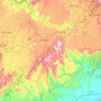
Name: Di Linh topographic map, elevation, terrain.
Location: Di Linh, Province de Lâm Đồng, Viêt Nam (11.21516 107.87440 11.82026 108.30678)
Average elevation: 728 m
Minimum elevation: 17 m
Maximum elevation: 1,802 m
Other topographic maps
Click on a map to view its topography, its elevation and its terrain.
Đà Lạt
Viêt Nam > Province de Lâm Đồng > Đà Lạt
Đà Lạt, Province de Lâm Đồng, 6700, Viêt Nam
Average elevation: 1,360 m