Geolocate

Angelus topographic map

Click on the map to display elevation.

About this map

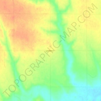
Name: Angelus topographic map, elevation, terrain.

Location: Angelus, Sheridan County, Kansas, United States (39.17112 -100.70431 39.21112 -100.66431)

Average elevation: 887 m

Minimum elevation: 862 m

Maximum elevation: 906 m

Other topographic maps

Click on a map to view its topography, its elevation and its terrain.

Hoxie

United States > Kansas > Sheridan County

Average elevation: 821 m

Gear up for your next adventure:

🥾Hiking Boots - Durable hiking boots for trails and rough terrain
🥾Hiking Shoes - Lightweight hiking shoes for day hikes
🔥Windproof Plasma Lighters - USB rechargeable lighters that work in high-altitude winds
🎒Tactical Waist Packs - Quick access to your compass, phone, and snacks while walking
🩹Blister Prevention Tape - Apply to friction points before they become painful sores

As an Amazon Associate, this site earns from qualifying purchases at no extra cost to you.