
Lens topographic map
Interactive map
Click on the map to display elevation.
About this map
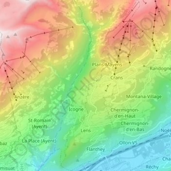
Name: Lens topographic map, elevation, terrain.
Location: Lens, Sierre, Valais/Wallis, 3960, Zwitserland (46.25920 7.42772 46.34629 7.48957)
Average elevation: 1,390 m
Minimum elevation: 499 m
Maximum elevation: 2,839 m
Other topographic maps
Click on a map to view its topography, its elevation and its terrain.
Anniviers
Zwitserland > Valais/Wallis > Sierre
Anniviers, Sierre, Valais/Wallis, 3961, Zwitserland
Average elevation: 2,310 m
Ayer
Zwitserland > Valais/Wallis > Sierre > Anniviers > Ayer
Ayer, Anniviers, Sierre, Valais/Wallis, 3961, Zwitserland
Average elevation: 1,858 m
Crans-Montana
Zwitserland > Valais/Wallis > Sierre
Crans-Montana, Sierre, Valais/Wallis, 3960, Zwitserland
Average elevation: 1,660 m
Sierre
Zwitserland > Valais/Wallis > Sierre
Sierre, Valais/Wallis, 3960, Zwitserland
Average elevation: 1,143 m