
Pulau Enggano topographic map
Interactive map
Click on the map to display elevation.
About this map
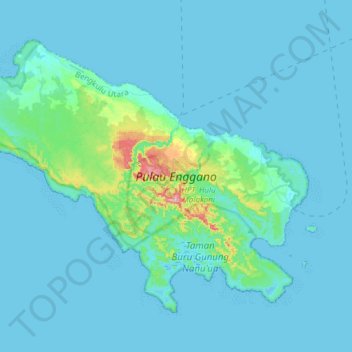
Name: Pulau Enggano topographic map, elevation, terrain.
Location: Pulau Enggano, Bengkulu Utara, Bengkulu, Sumatra, Indonesia (-5.51444 102.08615 -5.28131 102.38886)
Average elevation: 19 m
Minimum elevation: -4 m
Maximum elevation: 256 m
Enggano is about 35 kilometres (22 miles) long from east to west and about 16 kilometres (9.9 miles) wide from north to south. Its area is 400.6 square kilometres (154.7 square miles) including four small offshore islands around its coast - Pulau Merbau, Pulau Dua and tiny Pulau Banggai off Enggano's east coast, and Pulau Satu off its south coast. The average elevation is about 100 metres (330 feet), and the highest point is 281 metres (922 feet).