
Phu Quoc Island topographic map
Interactive map
Click on the map to display elevation.
About this map
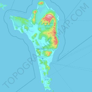
Name: Phu Quoc Island topographic map, elevation, terrain.
Location: Phu Quoc Island, Kiên Giang Province, Vietnam (10.00497 103.83250 10.45260 104.08222)
Average elevation: 17 m
Minimum elevation: 0 m
Maximum elevation: 530 m
Other topographic maps
Click on a map to view its topography, its elevation and its terrain.
Phu Quoc City
Vietnam > Kien Giang Province > Phu Quoc City
Phu Quoc City, Kien Giang Province, Vietnam
Average elevation: 3 m