
Make a donation
Gear up for your next adventure:
As an Amazon Associate, this site earns from qualifying purchases at no extra cost to you.
Neustadt (Hessen) topographic map
Click on the map to display elevation.
Make a donation
Gear up for your next adventure:
As an Amazon Associate, this site earns from qualifying purchases at no extra cost to you.
About this map
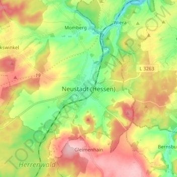
Name: Neustadt (Hessen) topographic map, elevation, terrain.
Average elevation: 292 m
Minimum elevation: 218 m
Maximum elevation: 381 m
Make a donation
Gear up for your next adventure:
As an Amazon Associate, this site earns from qualifying purchases at no extra cost to you.
Other topographic maps
Click on a map to view its topography, its elevation and its terrain.
Neustadt
Deutschland > Hessen > Landkreis Marburg-Biedenkopf > Neustadt
Hier steht mit einer Gesamthöhe von über 50 m und einem Durchmesser von rund 13 m der größte Fachwerkrundbau der Welt, der Junker-Hansen-Turm. Er ist ein eigentlich als Turm der Stadtmauer gebautes Befestigungswerk, das 1480 vom Festungsbaumeister Hans Jakob von Ettlingen über den 1470 abgebrochenen…
Average elevation: 295 m