
Los Alamos County topographic map
Interactive map
Click on the map to display elevation.
About this map
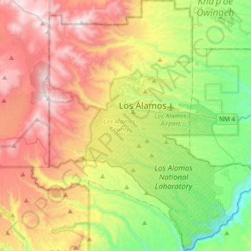
Name: Los Alamos County topographic map, elevation, terrain.
Location: Los Alamos County, Nieuw-Mexico, VS (35.75427 -106.41886 35.97344 -106.17166)
Average elevation: 2,315 m
Minimum elevation: 1,641 m
Maximum elevation: 3,205 m
Other topographic maps
Click on a map to view its topography, its elevation and its terrain.
Puesta Del Sol
VS > Nieuw-Mexico > Puesta Del Sol
Puesta Del Sol, Sandoval County, Nieuw-Mexico, 87043, VS
Average elevation: 1,807 m
Chaco Culture National Historical Park
Chaco Culture National Historical Park, Chaco Loop Road, San Juan County, Nieuw-Mexico, VS
Average elevation: 1,919 m
Santa Fe
VS > Nieuw-Mexico > Santa Fe
Santa Fe, Santa Fe County, Nieuw-Mexico, VS
Average elevation: 2,222 m
Los Alamos
VS > Nieuw-Mexico > Los Alamos
Los Alamos, Los Alamos County, Nieuw-Mexico, VS
Average elevation: 2,231 m
Rio Grande
VS > Nieuw-Mexico > La Joya
Rio Grande, Del Rio Camino, La Joya, Socorro County, Nieuw-Mexico, 87028-9998, VS
Average elevation: 1,502 m