
Arroyo Grande topographic map
Interactive map
Click on the map to display elevation.
About this map
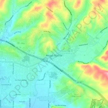
Name: Arroyo Grande topographic map, elevation, terrain.
Average elevation: 52 m
Minimum elevation: 4 m
Maximum elevation: 148 m
Other topographic maps
Click on a map to view its topography, its elevation and its terrain.
Nipomo
United States > California > San Luis Obispo County
Nipomo, San Luis Obispo County, California, 93444, United States
Average elevation: 107 m
Paso Robles
United States > California > San Luis Obispo County
Paso Robles, San Luis Obispo County, California, United States
Average elevation: 298 m