
Make a donation
Gear up for your next adventure:
As an Amazon Associate, this site earns from qualifying purchases at no extra cost to you.
Botovo topographic map
Click on the map to display elevation.
Make a donation
Gear up for your next adventure:
As an Amazon Associate, this site earns from qualifying purchases at no extra cost to you.
About this map
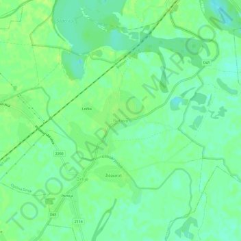
Name: Botovo topographic map, elevation, terrain.
Average elevation: 127 m
Minimum elevation: 119 m
Maximum elevation: 133 m
Make a donation
Gear up for your next adventure:
As an Amazon Associate, this site earns from qualifying purchases at no extra cost to you.
Other topographic maps
Click on a map to view its topography, its elevation and its terrain.
Make a donation
Gear up for your next adventure:
As an Amazon Associate, this site earns from qualifying purchases at no extra cost to you.
Grad Križevci
Croatia > Koprivnica-Križevci County
Topographically, it lies on Pleistocene foundations, between swamped alluvial valleys of the brook Vrtlin from the east and the brook Koruska from the west. Relief, geological-petrografical structure, convenient climate and abundance of water, all contribute to the economic and demographic development of the…
Average elevation: 196 m