
Make a donation
Gear up for your next adventure:
As an Amazon Associate, this site earns from qualifying purchases at no extra cost to you.
Mount Stromlo topographic map
Click on the map to display elevation.
Make a donation
Gear up for your next adventure:
As an Amazon Associate, this site earns from qualifying purchases at no extra cost to you.
About this map
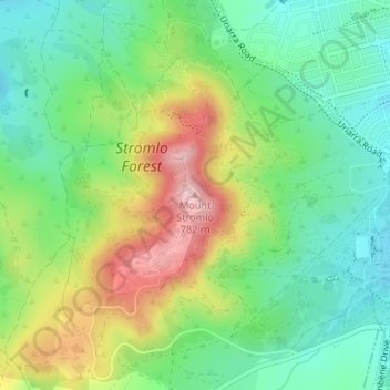
Name: Mount Stromlo topographic map, elevation, terrain.
Average elevation: 655 m
Minimum elevation: 580 m
Maximum elevation: 782 m
Australia trails, hiking, mountain biking, running and outdoor activities
Make a donation
Gear up for your next adventure:
As an Amazon Associate, this site earns from qualifying purchases at no extra cost to you.
Other topographic maps
Click on a map to view its topography, its elevation and its terrain.
Lake Burley Griffin
Charles Robert Scrivener (1855–1923) recommended the site for Canberra in 1909, which was to be a planned capital city for the country. One of the reasons for the location's selection was its ability to store water "for ornamental purposes at reasonable cost"; Scrivener's work had demonstrated that the…
Average elevation: 589 m
Make a donation
Gear up for your next adventure:
As an Amazon Associate, this site earns from qualifying purchases at no extra cost to you.
Make a donation
Gear up for your next adventure:
As an Amazon Associate, this site earns from qualifying purchases at no extra cost to you.