
Kolonie Nollendorf topographic map
Interactive map
Click on the map to display elevation.
About this map
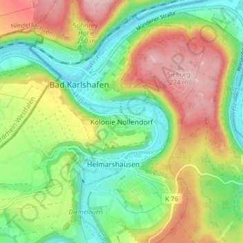
Name: Kolonie Nollendorf topographic map, elevation, terrain.
Average elevation: 173 m
Minimum elevation: 93 m
Maximum elevation: 285 m
Other topographic maps
Click on a map to view its topography, its elevation and its terrain.
Diemelhöhe
Deutschland > Hessen > Landkreis Kassel > Bad Karlshafen > Kolonie Nollendorf
Diemelhöhe, Kolonie Nollendorf, Bad Karlshafen, Landkreis Kassel, Hessen, 34385, Deutschland
Average elevation: 170 m
Barockhafen Bad Karlshafen
Deutschland > Hessen > Landkreis Kassel > Bad Karlshafen > Kolonie Nollendorf
Barockhafen Bad Karlshafen, Kolonie Nollendorf, Bad Karlshafen, Landkreis Kassel, Hessen, 34385, Deutschland
Average elevation: 166 m