
Make a donation
Gear up for your next adventure:
As an Amazon Associate, this site earns from qualifying purchases at no extra cost to you.
Flattach topographic map
Click on the map to display elevation.
Make a donation
Gear up for your next adventure:
As an Amazon Associate, this site earns from qualifying purchases at no extra cost to you.
About this map
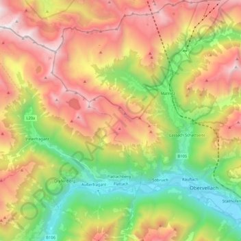
Name: Flattach topographic map, elevation, terrain.
Location: Flattach, Bezirk Spittal an der Drau, Carinthia, 9831, Austria (46.90132 12.98328 47.04387 13.14851)
Average elevation: 1,718 m
Minimum elevation: 657 m
Maximum elevation: 2,991 m
Make a donation
Gear up for your next adventure:
As an Amazon Associate, this site earns from qualifying purchases at no extra cost to you.
Other topographic maps
Click on a map to view its topography, its elevation and its terrain.
Seebach
Austria > Carinthia > Bezirk Spittal an der Drau > Seeboden am Millstätter See
Average elevation: 654 m
Innerkrems
Austria > Carinthia > Bezirk Spittal an der Drau > Krems in Kärnten
Average elevation: 1,811 m