
Grimal topographic map
Interactive map
Click on the map to display elevation.
About this map
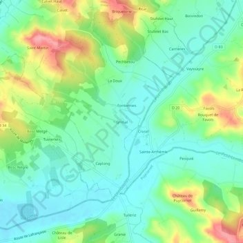
Name: Grimal topographic map, elevation, terrain.
Average elevation: 128 m
Minimum elevation: 93 m
Maximum elevation: 200 m
Other topographic maps
Click on a map to view its topography, its elevation and its terrain.
Calvet Haut
France > Occitanie > Tarn-et-Garonne > Labarthe > Calvet Haut
Calvet Haut, Labarthe, Montauban, Tarn-et-Garonne, Occitanie, France métropolitaine, 82220, France
Average elevation: 138 m