
Make a donation
Gear up for your next adventure:
As an Amazon Associate, this site earns from qualifying purchases at no extra cost to you.
Kopparberg topographic map
Click on the map to display elevation.
Make a donation
Gear up for your next adventure:
As an Amazon Associate, this site earns from qualifying purchases at no extra cost to you.
Kopparberg
Although Kopparberg is slightly further south, it is located at a slightly higher elevation 6 kilometres (3.7 mi) south-east, rendering likely values very similar. Winter highs usually average just below freezing, and frosts are frequent from October through April. Summers are very tempered, compared to both the Mälar Valley to the south and east and central Dalarna to the north. The warmest recorded temperature of 34.2 °C (93.6 °F) is still high by Swedish standards, courtesy of the unpredictability of its far inland position.
Make a donation
Gear up for your next adventure:
As an Amazon Associate, this site earns from qualifying purchases at no extra cost to you.
About this map
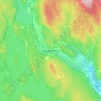
Name: Kopparberg topographic map, elevation, terrain.
Average elevation: 196 m
Minimum elevation: 106 m
Maximum elevation: 380 m
Make a donation
Gear up for your next adventure:
As an Amazon Associate, this site earns from qualifying purchases at no extra cost to you.