
Make a donation
Gear up for your next adventure:
As an Amazon Associate, this site earns from qualifying purchases at no extra cost to you.
Knapton topographic map
Click on the map to display elevation.
Make a donation
Gear up for your next adventure:
As an Amazon Associate, this site earns from qualifying purchases at no extra cost to you.
Knapton
The present church dates from mainly the 14th century. The tower is set into the north west corner of the building. The porch is on the southern elevation. Atop of the church there is a weathervane designed by J.S. Cotman an artist famed as a member of the Norwich school. Inside there is a 13th-century font on three high steps which has a Purbeck marble bowl and a cover over which dates from 1704. The inscription which is in Greek reads "wash my sins and not my face only" The inscription is a palindrome, reading the same backwards as forwards.. At the back of the church behind the font there are some coffin-lids from the earlier church set into the flags of the floor. The most prominent feature of this church is the roof. The roof was given to the church by a John Smithe in 1504. It is of a double hammerbeam construction and still retains its original colour. The beams and spandrels are richly carved with three tiers of angels which have outspread wings. More angels are carved on the kingposts and on the wall plate. In niches below the wall supports there are figures with scrolls, shields, symbols or playing musical instruments. The church is a Grade I listed building.
Make a donation
Gear up for your next adventure:
As an Amazon Associate, this site earns from qualifying purchases at no extra cost to you.
About this map
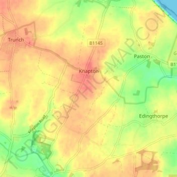
Name: Knapton topographic map, elevation, terrain.
Location: Knapton, North Norfolk, Norfolk, England, United Kingdom (52.83071 1.39914 52.87126 1.43681)
Average elevation: 29 m
Minimum elevation: 0 m
Maximum elevation: 46 m
Make a donation
Gear up for your next adventure:
As an Amazon Associate, this site earns from qualifying purchases at no extra cost to you.
Other topographic maps
Click on a map to view its topography, its elevation and its terrain.
Beacon Hill
United Kingdom > England > Norfolk > North Norfolk
Beacon Hill is a part of the Cromer Ridge which is a ridge of old glacial moraines (terminal moraine) that stands next to the coast above Cromer. The Cromer Ridge seems to have been the front line of the ice sheet for some time at the last glaciations, which is shown by the large size of the feature. All the…
Average elevation: 65 m
Make a donation
Gear up for your next adventure:
As an Amazon Associate, this site earns from qualifying purchases at no extra cost to you.
Ridlington
United Kingdom > England > Norfolk > North Norfolk > Witton and Ridlington
Average elevation: 9 m
Make a donation
Gear up for your next adventure:
As an Amazon Associate, this site earns from qualifying purchases at no extra cost to you.
Whimpwell Green
United Kingdom > England > Norfolk > North Norfolk > Happisburgh
Average elevation: 4 m
Make a donation
Gear up for your next adventure:
As an Amazon Associate, this site earns from qualifying purchases at no extra cost to you.
Make a donation
Gear up for your next adventure:
As an Amazon Associate, this site earns from qualifying purchases at no extra cost to you.
Make a donation
Gear up for your next adventure:
As an Amazon Associate, this site earns from qualifying purchases at no extra cost to you.
North Walsham and Dilham Canal
United Kingdom > England > Norfolk > North Norfolk > Honing
Average elevation: 21 m
Beeston Bump
United Kingdom > England > Norfolk > North Norfolk > Sheringham > Beeston Regis
Average elevation: 20 m
Make a donation
Gear up for your next adventure:
As an Amazon Associate, this site earns from qualifying purchases at no extra cost to you.
Stalham Green
United Kingdom > England > Norfolk > North Norfolk > Stalham Green
Average elevation: 5 m
Newgate
United Kingdom > England > Norfolk > North Norfolk > Cley next the Sea > Newgate
Average elevation: 22 m
Bacton Green
United Kingdom > England > Norfolk > North Norfolk > Bacton > Bacton Green
Average elevation: 9 m
West Raynham
United Kingdom > England > Norfolk > North Norfolk > West Raynham
Average elevation: 59 m
Make a donation
Gear up for your next adventure:
As an Amazon Associate, this site earns from qualifying purchases at no extra cost to you.
Sheringham Park
United Kingdom > England > Norfolk > North Norfolk > Upper Sheringham
Average elevation: 61 m
Johnson Street
United Kingdom > England > Norfolk > North Norfolk > Ludham > Johnson Street
Average elevation: 3 m
Make a donation
Gear up for your next adventure:
As an Amazon Associate, this site earns from qualifying purchases at no extra cost to you.