
Gschwendt topographic map
Interactive map
Click on the map to display elevation.
About this map
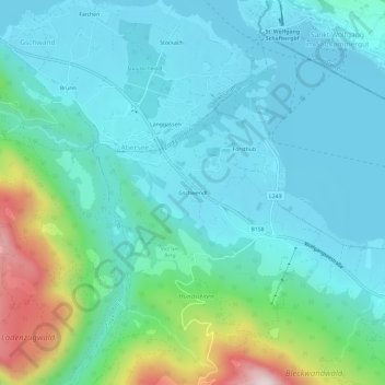
Name: Gschwendt topographic map, elevation, terrain.
Average elevation: 652 m
Minimum elevation: 528 m
Maximum elevation: 1,152 m
Other topographic maps
Click on a map to view its topography, its elevation and its terrain.
Postalm
Österreich > Salzburg > Bezirk Salzburg-Umgebung > Strobl > Lochalm
Postalm, Lochalm, Strobl, Bezirk Salzburg-Umgebung, Salzburg, 5350, Österreich
Average elevation: 1,311 m
Strobl
Österreich > Salzburg > Bezirk Salzburg-Umgebung > Strobl
Strobl, Bezirk Salzburg-Umgebung, Salzburg, 5350, Österreich
Average elevation: 999 m