
Make a donation
Gear up for your next adventure:
As an Amazon Associate, this site earns from qualifying purchases at no extra cost to you.
Manicouagan topographic map
Click on the map to display elevation.
Make a donation
Gear up for your next adventure:
As an Amazon Associate, this site earns from qualifying purchases at no extra cost to you.
About this map
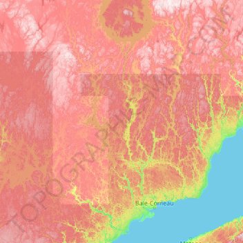
Name: Manicouagan topographic map, elevation, terrain.
Location: Manicouagan, Côte-Nord, Quebec, Canada (48.79653 -70.02562 51.57176 -66.99900)
Average elevation: 437 m
Minimum elevation: 0 m
Maximum elevation: 1,072 m
Make a donation
Gear up for your next adventure:
As an Amazon Associate, this site earns from qualifying purchases at no extra cost to you.
Other topographic maps
Click on a map to view its topography, its elevation and its terrain.
Make a donation
Gear up for your next adventure:
As an Amazon Associate, this site earns from qualifying purchases at no extra cost to you.
Big Hill
Canada > Quebec > communauté maritime des Îles-de-la-Madeleine > Les Îles-de-la-Madeleine
Average elevation: 21 m