
XIV. kerület topographic map
Interactive map
Click on the map to display elevation.
About this map
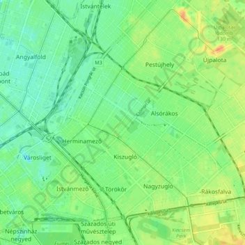
Name: XIV. kerület topographic map, elevation, terrain.
Location: XIV. kerület, Budapest, Hongrie centrale, Hongrie (47.49965 19.07235 47.54620 19.15705)
Average elevation: 116 m
Minimum elevation: 102 m
Maximum elevation: 137 m
Other topographic maps
Click on a map to view its topography, its elevation and its terrain.
XII. kerület
XII. kerület, Budapest, Hongrie centrale, Hongrie
Average elevation: 267 m
Csúcs-hegy
Csúcs-hegy, Budapest, Hongrie centrale, 1285, Hongrie
Average elevation: 261 m
Terézváros
Terézváros, 6. kerület, Budapest, Hongrie centrale, Hongrie
Average elevation: 114 m
Városliget
Városliget, 14. kerület, Budapest, Hongrie centrale, Hongrie
Average elevation: 113 m