
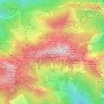
Kampenwand-Hauptgipfel topographic map
Interactive map
Click on the map to display elevation.
About this map
Name: Kampenwand-Hauptgipfel topographic map, elevation, terrain.
Average elevation: 1,272 m
Minimum elevation: 857 m
Maximum elevation: 1,617 m
Other topographic maps
Click on a map to view its topography, its elevation and its terrain.
Hammerbach
Deutschland > Bayern > Landkreis Rosenheim > Aschau im Chiemgau
Hammerbach, Aschau im Chiemgau, Landkreis Rosenheim, Bayern, 83229, Deutschland
Average elevation: 871 m
Hohenaschau
Deutschland > Bayern > Landkreis Rosenheim > Aschau im Chiemgau
Hohenaschau, Aschau im Chiemgau, Landkreis Rosenheim, Bayern, 83229, Deutschland
Average elevation: 863 m
Goriloch
Deutschland > Bayern > Landkreis Rosenheim > Aschau im Chiemgau > Goriloch
Goriloch, Aschau im Chiemgau, Landkreis Rosenheim, Bayern, 83229, Deutschland
Average elevation: 1,105 m
Geigelstein
Deutschland > Bayern > Landkreis Rosenheim > Aschau im Chiemgau
Geigelstein, Aschau im Chiemgau, Landkreis Rosenheim, Bayern, Deutschland
Average elevation: 1,443 m
Kohlstatt
Deutschland > Bayern > Landkreis Rosenheim > Aschau im Chiemgau > Kohlstatt
Kohlstatt, Aschau im Chiemgau, Landkreis Rosenheim, Bayern, 83229, Deutschland
Average elevation: 793 m
Staffelstein
Deutschland > Bayern > Landkreis Rosenheim > Aschau im Chiemgau
Staffelstein, Aschau im Chiemgau, Landkreis Rosenheim, Bayern, Deutschland
Average elevation: 1,258 m