
Make a donation
Gear up for your next adventure:
As an Amazon Associate, this site earns from qualifying purchases at no extra cost to you.
McDermitt topographic map
Click on the map to display elevation.
Make a donation
Gear up for your next adventure:
As an Amazon Associate, this site earns from qualifying purchases at no extra cost to you.
McDermitt
The community is on U.S. Highway 95, 73 miles (117 km) north of Winnemucca. The elevation of McDermitt is 4,432 feet (1,351 m) above sea level.
Make a donation
Gear up for your next adventure:
As an Amazon Associate, this site earns from qualifying purchases at no extra cost to you.
About this map
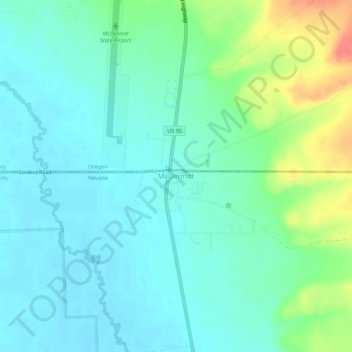
Name: McDermitt topographic map, elevation, terrain.
Location: McDermitt, Humboldt County, Nevada, 89421, United States (41.97783 -117.73750 42.01783 -117.69750)
Average elevation: 1,359 m
Minimum elevation: 1,344 m
Maximum elevation: 1,403 m
Make a donation
Gear up for your next adventure:
As an Amazon Associate, this site earns from qualifying purchases at no extra cost to you.
Other topographic maps
Click on a map to view its topography, its elevation and its terrain.
North Jackson Mountains Wilderness
United States > Nevada > Humboldt County
Average elevation: 1,747 m
Make a donation
Gear up for your next adventure:
As an Amazon Associate, this site earns from qualifying purchases at no extra cost to you.