
Whaddon topographic map
Click on the map to display elevation.
About this map
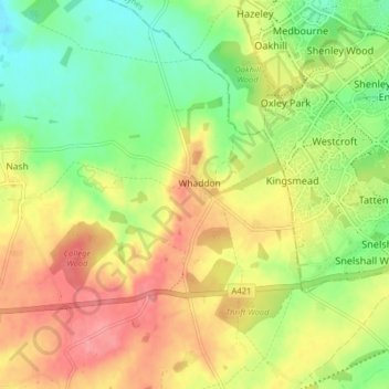
Name: Whaddon topographic map, elevation, terrain.
Location: Whaddon, Buckinghamshire, England, United Kingdom (51.97334 -0.85384 52.02236 -0.80353)
Average elevation: 114 m
Minimum elevation: 74 m
Maximum elevation: 156 m
Other topographic maps
Click on a map to view its topography, its elevation and its terrain.
Hotley Bottom
United Kingdom > England > Buckinghamshire > Great Missenden > Prestwood
Average elevation: 182 m
Wapsey's Wood Landfill Site
United Kingdom > England > Buckinghamshire > Beaconsfield > Jordans
Average elevation: 93 m
Doddershall Wood
United Kingdom > England > Buckinghamshire > Grendon Underwood
Average elevation: 77 m