
Guarulhos topographic map
Interactive map
Click on the map to display elevation.
About this map
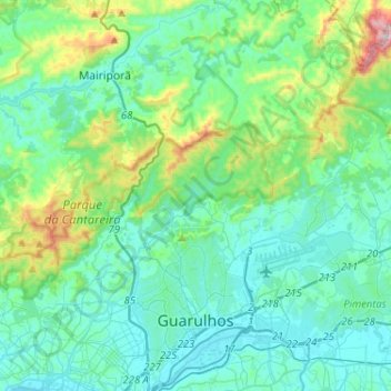
Name: Guarulhos topographic map, elevation, terrain.
Average elevation: 841 m
Minimum elevation: 718 m
Maximum elevation: 1,413 m
Other topographic maps
Click on a map to view its topography, its elevation and its terrain.
Embu das Artes
Brazil > São Paulo > Região Metropolitana de São Paulo
Embu das Artes, Região Imediata de São Paulo, Região Metropolitana de São Paulo, Região Geográfica Intermediária de São Paulo, São Paulo, Southeast Region, Brazil
Average elevation: 811 m
São Paulo
Brazil > São Paulo > Região Metropolitana de São Paulo > São Paulo
São Paulo, Região Imediata de São Paulo, Região Metropolitana de São Paulo, Região Geográfica Intermediária de São Paulo, São Paulo, Southeast Region, 01001-000, Brazil
Average elevation: 785 m
Atlantic Forest
Brazil > São Paulo > Região Metropolitana de São Paulo > Ribeirão Pires
Atlantic Forest, Vila Mara, Ribeirão Pires, Região Imediata de São Paulo, Região Metropolitana de São Paulo, Região Geográfica Intermediária de São Paulo, São Paulo, Southeast Region, Brazil
Average elevation: 787 m
Santa Isabel
Brazil > São Paulo > Região Metropolitana de São Paulo > Santa Isabel
Santa Isabel, Região Imediata de São Paulo, Região Metropolitana de São Paulo, Região Geográfica Intermediária de São Paulo, São Paulo, Southeast Region, 07500-000, Brazil
Average elevation: 730 m
São Paulo
Brazil > São Paulo > Região Metropolitana de São Paulo
São Paulo, Região Imediata de São Paulo, Região Metropolitana de São Paulo, Região Geográfica Intermediária de São Paulo, São Paulo, Southeast Region, Brazil
Average elevation: 716 m