
Make a donation
Gear up for your next adventure:
As an Amazon Associate, this site earns from qualifying purchases at no extra cost to you.
Qom topographic map
Click on the map to display elevation.
Make a donation
Gear up for your next adventure:
As an Amazon Associate, this site earns from qualifying purchases at no extra cost to you.
Qom
The city's topography in the 10th century still reflected the evolutionary merging of the original six villages; these were still separated by fields. The town center was located in the village of Mamajjān, which was connected to other parts of the city on the other side of the river by four bridges. There were about eight squares whose function is not clear and three mosques within the city. There is almost no information about madrasas. The sanctuary must have still been quite small as only two cupolas are mentioned. A bazaar and bathhouses must have existed, too, as well as certain administrative buildings (prison, mint). Five bigger and eight smaller roads indicate good traffic connections, which were supported by at least three or maybe even nine city gates.
Make a donation
Gear up for your next adventure:
As an Amazon Associate, this site earns from qualifying purchases at no extra cost to you.
About this map
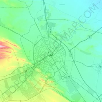
Name: Qom topographic map, elevation, terrain.
Location: Qom, Qom Central District, Qom County, Qom Province, Iran (34.52552 50.73317 34.77500 50.95022)
Average elevation: 943 m
Minimum elevation: 846 m
Maximum elevation: 1,440 m
Make a donation
Gear up for your next adventure:
As an Amazon Associate, this site earns from qualifying purchases at no extra cost to you.