
Make a donation
Gear up for your next adventure:
As an Amazon Associate, this site earns from qualifying purchases at no extra cost to you.
Austerby topographic map
Click on the map to display elevation.
Make a donation
Gear up for your next adventure:
As an Amazon Associate, this site earns from qualifying purchases at no extra cost to you.
About this map
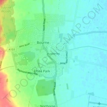
Name: Austerby topographic map, elevation, terrain.
Average elevation: 14 m
Minimum elevation: 0 m
Maximum elevation: 56 m
Make a donation
Gear up for your next adventure:
As an Amazon Associate, this site earns from qualifying purchases at no extra cost to you.
Other topographic maps
Click on a map to view its topography, its elevation and its terrain.
Carlton Scroop
United Kingdom > England > Lincolnshire > South Kesteven > Carlton Scroop
Average elevation: 64 m
Make a donation
Gear up for your next adventure:
As an Amazon Associate, this site earns from qualifying purchases at no extra cost to you.
Make a donation
Gear up for your next adventure:
As an Amazon Associate, this site earns from qualifying purchases at no extra cost to you.
Witham on the Hill
United Kingdom > England > Lincolnshire > South Kesteven > Witham on the Hill
Average elevation: 45 m
Make a donation
Gear up for your next adventure:
As an Amazon Associate, this site earns from qualifying purchases at no extra cost to you.
Uffington Park
United Kingdom > England > Lincolnshire > South Kesteven > Uffington
Average elevation: 30 m
Make a donation
Gear up for your next adventure:
As an Amazon Associate, this site earns from qualifying purchases at no extra cost to you.
Little Bytham
United Kingdom > England > Lincolnshire > South Kesteven > Little Bytham
Average elevation: 62 m
Deeping St. James
United Kingdom > England > Lincolnshire > South Kesteven > Frognall
Average elevation: 5 m
Woolsthorpe By Belvoir
United Kingdom > England > Lincolnshire > South Kesteven > Woolsthorpe-by-Belvoir
Average elevation: 74 m
Make a donation
Gear up for your next adventure:
As an Amazon Associate, this site earns from qualifying purchases at no extra cost to you.
Allington
United Kingdom > England > Lincolnshire > South Kesteven > Allington
Average elevation: 37 m
Make a donation
Gear up for your next adventure:
As an Amazon Associate, this site earns from qualifying purchases at no extra cost to you.
Witham on the Hill
United Kingdom > England > Lincolnshire > South Kesteven > Witham on the Hill
Average elevation: 45 m