
Altdorf (UR) topographic map
Interactive map
Click on the map to display elevation.
About this map
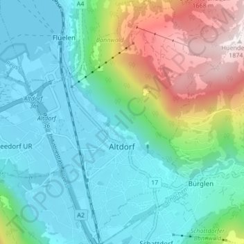
Name: Altdorf (UR) topographic map, elevation, terrain.
Location: Altdorf (UR), Uri, 6460, Zwitserland (46.86364 8.61551 46.90976 8.66732)
Average elevation: 796 m
Minimum elevation: 431 m
Maximum elevation: 1,859 m
Altdorf ligt op 458 meter hoogte, heeft een oppervlakte van 10,23 km² en telt circa 9.000 inwoners. Bij Altdorf stroomt de rivier Reuss in het meer van Luzern in het gedeelte van het meer dat meer van Uri heet (Urnersee).
Other topographic maps
Click on a map to view its topography, its elevation and its terrain.
Piz Badus
Zwitserland > Uri > Korporation Ursern > Andermatt
Piz Badus, Andermatt, Korporation Ursern, Uri, 6490, Zwitserland
Average elevation: 2,410 m
Furkapass
Zwitserland > Uri > Realp
Furkapass, Realp, Korporation Ursern, Uri, 6491, Zwitserland
Average elevation: 2,470 m
Andermatt
Zwitserland > Uri > Korporation Ursern
Andermatt, Korporation Ursern, Uri, 6490, Zwitserland
Average elevation: 2,127 m
Oberalpstock
Zwitserland > Uri > Silenen
Oberalpstock, Silenen, Uri, Zwitserland
Average elevation: 2,711 m