
Thank you for supporting this site ❤️
Make a donation
Make a donation
Gear up for your next adventure:
As an Amazon Associate, this site earns from qualifying purchases at no extra cost to you.
Bonbaden topographic map
Click on the map to display elevation.
Thank you for supporting this site ❤️
Make a donation
Make a donation
Gear up for your next adventure:
As an Amazon Associate, this site earns from qualifying purchases at no extra cost to you.
About this map
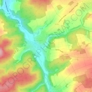
Name: Bonbaden topographic map, elevation, terrain.
Location: Bonbaden, Braunfels, Lahn-Dill-Kreis, Hessen, Deutschland (50.48256 8.39598 50.51637 8.45164)
Average elevation: 234 m
Minimum elevation: 156 m
Maximum elevation: 311 m
Thank you for supporting this site ❤️
Make a donation
Make a donation
Gear up for your next adventure:
As an Amazon Associate, this site earns from qualifying purchases at no extra cost to you.