
Riedlberg topographic map
Interactive map
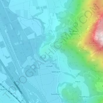
Click on the map to display elevation.
About this map
Name: Riedlberg topographic map, elevation, terrain.
Average elevation: 574 m
Minimum elevation: 449 m
Maximum elevation: 1,261 m
Other topographic maps
Click on a map to view its topography, its elevation and its terrain.
Niederthann
Deutschland > Bayern > Landkreis Rosenheim > Nußdorf am Inn
Niederthann, Nußdorf am Inn, Landkreis Rosenheim, Bayern, 83131, Deutschland
Average elevation: 556 m
Untersulzberg
Deutschland > Bayern > Landkreis Rosenheim > Nußdorf am Inn > Untersulzberg
Untersulzberg, Nußdorf am Inn, Landkreis Rosenheim, Bayern, 83131, Deutschland
Average elevation: 638 m