
Make a donation
Gear up for your next adventure:
As an Amazon Associate, this site earns from qualifying purchases at no extra cost to you.
Philippsburg topographic map
Click on the map to display elevation.
Make a donation
Gear up for your next adventure:
As an Amazon Associate, this site earns from qualifying purchases at no extra cost to you.
About this map
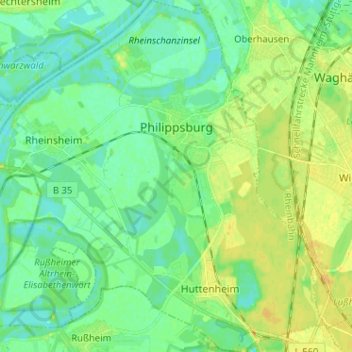
Name: Philippsburg topographic map, elevation, terrain.
Average elevation: 101 m
Minimum elevation: 92 m
Maximum elevation: 114 m
Make a donation
Gear up for your next adventure:
As an Amazon Associate, this site earns from qualifying purchases at no extra cost to you.
Other topographic maps
Click on a map to view its topography, its elevation and its terrain.
Schluttenbach
Deutschland > Baden-Württemberg > Landkreis Karlsruhe > Ettlingen
Average elevation: 328 m
Untergrombach
Deutschland > Baden-Württemberg > Landkreis Karlsruhe > Bruchsal
Average elevation: 156 m
Make a donation
Gear up for your next adventure:
As an Amazon Associate, this site earns from qualifying purchases at no extra cost to you.
Rußheimer Altrhein
Deutschland > Baden-Württemberg > Landkreis Karlsruhe > Philippsburg
Average elevation: 99 m
Make a donation
Gear up for your next adventure:
As an Amazon Associate, this site earns from qualifying purchases at no extra cost to you.
Waldprechtsweier
Deutschland > Baden-Württemberg > Landkreis Karlsruhe > Malsch
Average elevation: 246 m
Pfaffenrot
Deutschland > Baden-Württemberg > Landkreis Karlsruhe
Marxzell liegt im Albtal und auf den Höhen des Nordschwarzwaldes.
Average elevation: 349 m
Bad Mingolsheim
Deutschland > Baden-Württemberg > Landkreis Karlsruhe > Bad Mingolsheim
Average elevation: 124 m
Make a donation
Gear up for your next adventure:
As an Amazon Associate, this site earns from qualifying purchases at no extra cost to you.
Make a donation
Gear up for your next adventure:
As an Amazon Associate, this site earns from qualifying purchases at no extra cost to you.
Langensteinbach
Deutschland > Baden-Württemberg > Landkreis Karlsruhe
Als Bestandteil der Markgrafschaft Baden-Durlach war Langensteinbach evangelisch geprägt. Heute sind in Langensteinbach fünf christliche Gemeinschaften vertreten: Die evangelische und katholische Kirchengemeinde, das überkonfessionelle Bibelkonferenzzentrum Langensteinbacher Höhe (LaHoe), das evangelische…
Average elevation: 284 m
Waghäusel
Deutschland > Baden-Württemberg > Landkreis Karlsruhe
Der Gemeinderat hat normalerweise 26 ehrenamtliche Mitglieder, die für fünf Jahre gewählt werden. Die Gemeinderäte führen die Bezeichnung Stadtrat. Die Zahl der Gemeinderäte kann sich durch Ausgleichssitze erhöhen (gesamt 2019: 28 Sitze; 2014: 29). Hinzu kommt der Bürgermeister als stimmberechtigter…
Average elevation: 104 m
Make a donation
Gear up for your next adventure:
As an Amazon Associate, this site earns from qualifying purchases at no extra cost to you.
Ölmühle
Deutschland > Baden-Württemberg > Landkreis Karlsruhe > Bretten > Ruit
Average elevation: 217 m
Ettlingenweier
Deutschland > Baden-Württemberg > Landkreis Karlsruhe > Ettlingen
Average elevation: 169 m
Make a donation
Gear up for your next adventure:
As an Amazon Associate, this site earns from qualifying purchases at no extra cost to you.
Obergrombach
Deutschland > Baden-Württemberg > Landkreis Karlsruhe > Bruchsal
Average elevation: 208 m
Make a donation
Gear up for your next adventure:
As an Amazon Associate, this site earns from qualifying purchases at no extra cost to you.
Insel Rott
Deutschland > Baden-Württemberg > Landkreis Karlsruhe > Linkenheim-Hochstetten
Average elevation: 99 m
Karlsdorf
Deutschland > Baden-Württemberg > Landkreis Karlsruhe > Karlsdorf-Neuthard
Average elevation: 111 m
Make a donation
Gear up for your next adventure:
As an Amazon Associate, this site earns from qualifying purchases at no extra cost to you.
Neurod
Deutschland > Baden-Württemberg > Landkreis Karlsruhe > Waldbronn > Etzenrot
Average elevation: 276 m
Reichenbach
Deutschland > Baden-Württemberg > Landkreis Karlsruhe > Waldbronn
Average elevation: 260 m
Make a donation
Gear up for your next adventure:
As an Amazon Associate, this site earns from qualifying purchases at no extra cost to you.
Rheinstetten
Deutschland > Baden-Württemberg > Landkreis Karlsruhe > Rheinstetten > Rheinstetten
Average elevation: 113 m
Unteröwisheim
Deutschland > Baden-Württemberg > Landkreis Karlsruhe > Unteröwisheim
Average elevation: 164 m
Oberhausen
Deutschland > Baden-Württemberg > Landkreis Karlsruhe > Oberhausen
Average elevation: 100 m
Linkenheim-Hochstetten
Deutschland > Baden-Württemberg > Landkreis Karlsruhe > Linkenheim-Hochstetten > Linkenheim-Hochstetten
Average elevation: 105 m
Make a donation
Gear up for your next adventure:
As an Amazon Associate, this site earns from qualifying purchases at no extra cost to you.
Dürrenbüchig
Deutschland > Baden-Württemberg > Landkreis Karlsruhe > Bretten > Dürrenbüchig
Average elevation: 220 m