
Make a donation
Gear up for your next adventure:
As an Amazon Associate, this site earns from qualifying purchases at no extra cost to you.
Tartar topographic map
Click on the map to display elevation.
Make a donation
Gear up for your next adventure:
As an Amazon Associate, this site earns from qualifying purchases at no extra cost to you.
About this map
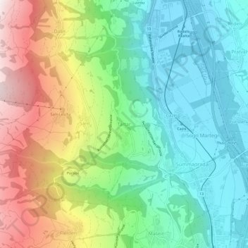
Name: Tartar topographic map, elevation, terrain.
Location: Tartar, Cazis, Viamala, Grisons, 7422, Switzerland (46.69982 9.39923 46.73982 9.43923)
Average elevation: 984 m
Minimum elevation: 635 m
Maximum elevation: 1,646 m
Make a donation
Gear up for your next adventure:
As an Amazon Associate, this site earns from qualifying purchases at no extra cost to you.
Other topographic maps
Click on a map to view its topography, its elevation and its terrain.
Make a donation
Gear up for your next adventure:
As an Amazon Associate, this site earns from qualifying purchases at no extra cost to you.
Mathon
Switzerland > Grisons > Viamala > Muntogna da Schons
Before 2017, the former municipality was located in the Schams sub-district, of the Hinterrhein district, after 2017 it was part of the Viamala Region. The village is a haufendorf (an irregular, unplanned and quite closely packed village, built around a central square) at an elevation of 1,521 m (4,990 ft) in…
Average elevation: 1,994 m
Lohn (GR)
Switzerland > Grisons > Viamala > Muntogna da Schons > Donat
Before 2017, the former municipality was located in the Schams sub-district, of the Hinterrhein district, after 2017 it was part of the Viamala Region. It is a haufendorf (an irregular, unplanned and quite closely packed village, built around a central square) located at an elevation of 1,582 m (5,190 ft) on…
Average elevation: 1,594 m
Make a donation
Gear up for your next adventure:
As an Amazon Associate, this site earns from qualifying purchases at no extra cost to you.
Avers
Switzerland > Grisons > Viamala
Avers (Romansh: Avras; Walser: Òòver(s), pronounced [ɔːfər], [ɔːfərs]) is a high Alpine valley region and a municipality in the Viamala Region in the Swiss canton of Graubünden. It includes Juf, the highest-altitude year-round settlement in Europe.
Average elevation: 2,407 m