Yan Yean topographic map
Interactive map
Click on the map to display elevation.
About this map
![Yan Yean topographic map, elevation, terrain](/pub/maps/node/7918/mnlw4214/thumbnail.jpg)
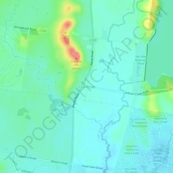
Name: Yan Yean topographic map, elevation, terrain.
Location: Yan Yean, City of Whittlesea, Victoria, 3755, Australia (-37.58913 145.08783 -37.54913 145.12783)
Average elevation: 182 m
Minimum elevation: 165 m
Maximum elevation: 245 m
Other topographic maps
Click on a map to view its topography, its elevation and its terrain.
![Yan Yean Reservoir topographic map, elevation, terrain](/pub/maps/way/14nx/kp2dkb3/icon.jpg)
Yan Yean Reservoir
Australia > Victoria > Yan Yean
Yan Yean Reservoir, Ridge Road, Yan Yean, City of Whittlesea, Victoria, 3755, Australia
Average elevation: 187 m
![Gunghalin Redgum Reserve topographic map, elevation, terrain](/pub/maps/way/19m/mj2pj18/icon.jpg)
Gunghalin Redgum Reserve
Australia > Victoria > Yan Yean
Gunghalin Redgum Reserve, Mitchells Run, Doreen, Yan Yean, City of Whittlesea, Victoria, 3755, Australia
Average elevation: 172 m