
Thank you for supporting this site ❤️
Make a donation
Make a donation
Gear up for your next adventure:
As an Amazon Associate, this site earns from qualifying purchases at no extra cost to you.
Tulancingo topographic map
Click on the map to display elevation.
Thank you for supporting this site ❤️
Make a donation
Make a donation
Gear up for your next adventure:
As an Amazon Associate, this site earns from qualifying purchases at no extra cost to you.
About this map
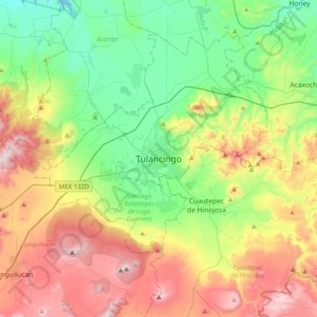
Name: Tulancingo topographic map, elevation, terrain.
Location: Tulancingo, Tulancingo de Bravo, Hidalgo, 43600, México (19.92396 -98.52354 20.24396 -98.20354)
Average elevation: 2,383 m
Minimum elevation: 2,019 m
Maximum elevation: 2,996 m
Thank you for supporting this site ❤️
Make a donation
Make a donation
Gear up for your next adventure:
As an Amazon Associate, this site earns from qualifying purchases at no extra cost to you.