
Ioco topographic map
Interactive map
Click on the map to display elevation.
About this map
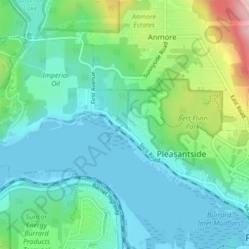
Name: Ioco topographic map, elevation, terrain.
Average elevation: 97 m
Minimum elevation: -1 m
Maximum elevation: 458 m
Other topographic maps
Click on a map to view its topography, its elevation and its terrain.
Burns Point
Canada > British Columbia > Metro Vancouver Regional District > Port Moody
Burns Point, Carraholly, Port Moody, Metro Vancouver Regional District, British Columbia, V5A 4V5, Canada
Average elevation: 94 m
Port Moody
Canada > British Columbia > Metro Vancouver Regional District > Port Moody
Port Moody, Metro Vancouver Regional District, British Columbia, V3H 5C3, Canada
Average elevation: 233 m