Geolocate

Elwick topographic map

Click on the map to display elevation.

About this map

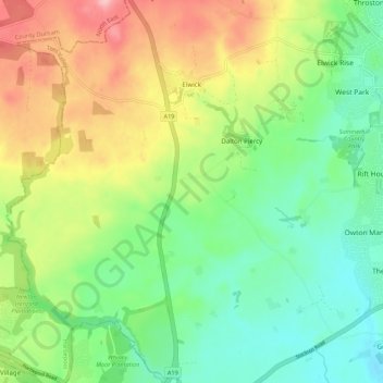
Name: Elwick topographic map, elevation, terrain.

Location: Elwick, Hartlepool, Tees Valley, England, United Kingdom (54.63500 -1.34784 54.69808 -1.26513)

Average elevation: 59 m

Minimum elevation: 2 m

Maximum elevation: 152 m

Other topographic maps

Click on a map to view its topography, its elevation and its terrain.

Hartlepool

United Kingdom > England > Hartlepool

Average elevation: 16 m

Teesmouth

United Kingdom > England > Hartlepool

Average elevation: 1 m

Hartlepool

United Kingdom > England > Hartlepool

Average elevation: 16 m

Gear up for your next adventure:

🍴Titanium Spork & Cutlery - Indestructible and feather-light eating utensils
🧦Hiking Socks - Comfortable socks for long hikes
🏫Topographic World Globes - 3D physical relief globes to understand global geography
📦Crushproof Equipment Cases - Safe transport for sensitive surveying and mapping instruments
🧢Wide Brim Sun Hats - Maximum coverage for the face and neck while out in the open

As an Amazon Associate, this site earns from qualifying purchases at no extra cost to you.