
Amazon rainforest topographic map
Interactive map
Click on the map to display elevation.
About this map
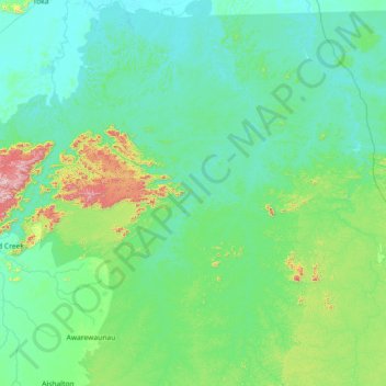
Name: Amazon rainforest topographic map, elevation, terrain.
Location: Amazon rainforest, Guyana (1.14800 -59.49698 3.90855 -58.09419)
Average elevation: 219 m
Minimum elevation: 71 m
Maximum elevation: 1,076 m
Other topographic maps
Click on a map to view its topography, its elevation and its terrain.
Jonestown
Guyana > Barima-Waini > Matthews Ridge - Arakaka (Matakai) - Port Kaituma
Average elevation: 29 m
No. 8 or Good Banana Land
Guyana > East Berbice-Corentyne > Cane Field - Enterprise > Cane Field
Average elevation: 3 m
No. 72 or Hong Kong
Guyana > East Berbice-Corentyne > No. 52 - No. 74 > No. 72 Village > No. 72 or Hong Kong
Average elevation: 2 m
Port Kaituma
Guyana > Barima-Waini > Matthews Ridge - Arakaka (Matakai) - Port Kaituma
Average elevation: 10 m